|
Reported Crop Circles for the State of Ohio -
Moscow, Clermont County (June 6, 2010)


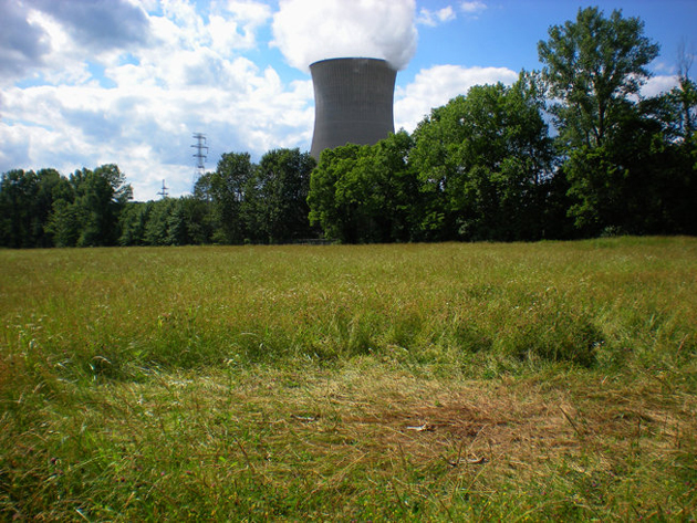
I [Jeffrey Wilson] spotted this circle on a drive along the Ohio River. It is located in a mixed grass field adjacent to the coal-fired Zimmer Power Plant (the nuclear cooling tower in the photo was designed and built in the 1980's, but the facility was changed to be coal-fired after the Three Mile Island nuclear accident and never had nuclear fuel there, but they still use the tower.).
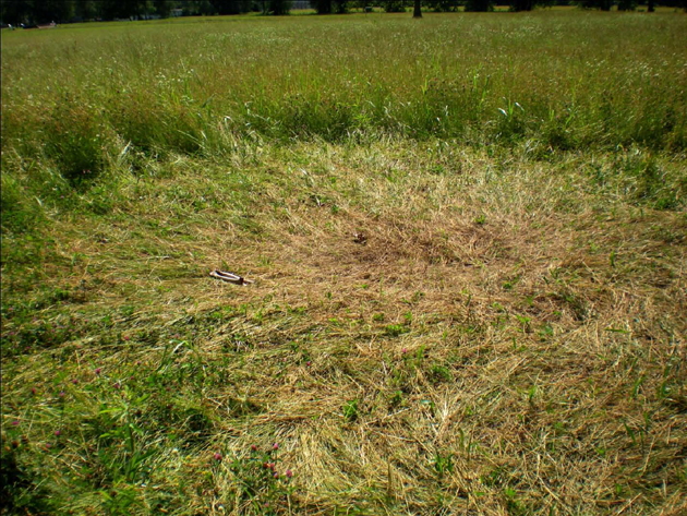
The circle was 18'10" N/S in diameter and 23'2" E/W in diameter. The additional flattened areas to the west were a combined 74 feet in length total, with several swirled areas and standing tufts.
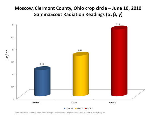
The circle was nearly entirely radially-flattened, and there several other non-geometric flattened areas connected to it via curved pathways. I was able to detect 2.6x higher radiation in the circle as compared to control readings. After much internal ICCRA discussion, we decided NOT to collect plant samples or examine plant samples, because of concerns regarding contamination due to the remnants of a deer that had been scattered throughout the formation. Deer bones and pieces were found throughout the formation, scattered by scavenger birds and possibly coyotes/dogs. The deer was NOT killed by the formation process - firefighters located across the street from the formation recalled seeing the dead deer that had been hit by a car alongside the edge of the road. The deer had been dragged into the formation AFTER the formation went down. All the bones and parts were lying on top of the flattened grass. It was creepy though... I did however measure for radioactivity:

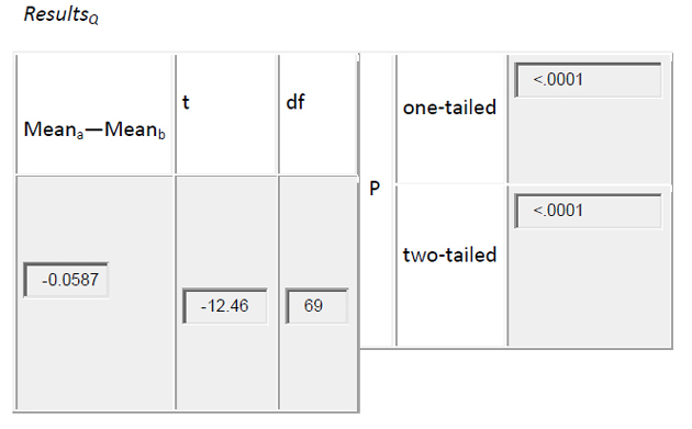
The radiation readings taken on June 10 inside the circle (Circle 1) were (on the average) over 2.5 times higher than the control readings. When using the Independent-samples t-Test at Vassar Stats, the statistical results were conclusive:

The probability (P) results of <.0001 for both the one-tailed and two-tailed indicates a very high statistical significance.
The field where this formation is located is just inside the village limits of Moscow, Ohio, and just to the east of Little Indian Creek. The formation is located about 4.5 miles north of the Edgington Mound and about 6 miles south of the Green Mound, and about 3/10ths of a mile from the Ohio River.
View more pictures and video here.
Crop
type: field grass
Source: Jeffrey Wilson, ICCRA investigation; Vassar Stats http://faculty.vassar.edu/lowry/t_ind_stats.html |
|
City
/ County / Date:
- Middletown,
Butler County (1941)
- Carolton
(now Carrolton / Center Township), Carrol County (1960)
- Dellroy,
Carroll County
(June 26, 1965)
- Gallipolis,
Gallia County (November 1966)
- Rush
County (1968)
- Meigs
County (1968)
- Columbus,
Franklin County (October 16, 1973)
- Mariemont,
Hamilton County (January 4, 1975)
- Lancaster,
Fairfield County (1977)
- Oak
Harbor, Ottawa County (1979)
- Helena,
Guernsey County (1986)
- Millersburg,
Holmes County (November 10, 1989)
- Millersburg,
Holmes County (February, 1991)
- Dundee,
Tuscarawas County (March 20, 1992)
- Austinberg
/ Ashtabula, Ashtabula County
(August 30, 1992)
- Worthington,
Franklin County (April 1995)
- Paulding
/ Jackson Township, Paulding County (July 4, 1996)
- Sugar
Creek Township / Elida, Allen County (August 1, 1996)
- Payne,
Paulding County
(June 27, 1997)
- Broughton
/ Latty Township, Paulding County (June 27, 1998)
- Lafayette,
Allen County
(June 1999)
- Bainbridge,
Ross County
(June 29, 2000)
- Careytown,
Highland County (June 24, 2002)
- Sardinia,
Brown County
(June 30, 2002)
- Locust
Grove, Adams County (August 24, 2003)
- Bourneville,
Ross County (September 6, 2003)
- Paint
Creek Island, Bainbridge, Ross County
(September 25, 2003)
- West
Union, Adams County (October 25, 2003)
- Cuba,
Clinton County
(June 15, 2004)
- Hillsboro,
Highland County
(July 5, 2004)
- West
Union, Adams County
(August 16, 2004)
- Miamisburg,
Montgomery County (August 24, 2004)
- Rarden,
Scioto County
(September 15, 2004)
- Patterson’s
Corner, Greene County (July 5, 2005)
- Yellow
Springs, Greene County (August 12, 2005)
- Fairfax,
Highland County
(April 21, 2006)
- Eagle
Township, Brown County (May 21, 2006)
- Newbury, Geauga
County
(July 7, 2006)
- Sandyville,
Tuscarawas County (July 22, 2006)
- Bucyrus, Crawford
County (August 31, 2006)
- Madisonburg,
Wayne County (September 1, 2007)
- Moscow, Clermont County
(June 6, 2010)
- Owensville, Clermont County
(June 24, 2010)
- Chillicothe, Ross County
(Mid Sept 2012)
|

